US Satellite Company Planet Labs Imposes Blackout on Middle East War Images After Trump Request
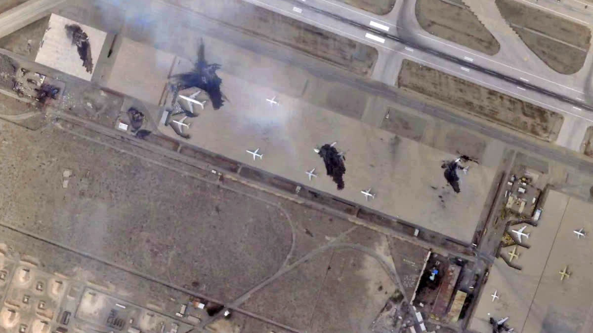
In a significant development, US satellite imagery company Planet Labs has announced that it will stop publishing high-resolution aerial pictures of the areas involved in the Middle East war. This decision comes after a request from the US government, led by President Donald Trump. The move is expected to last until the end of the conflict, which has been escalating since late February.
The United States and Israel have been conducting joint strikes against Iran, prompting the Islamic Republic to retaliate with daily missile barrages targeting Israel and several neighboring countries across the region. In response to the growing tensions, Planet Labs has decided to implement an indefinite withhold of imagery, effective retroactively from March 9, 2026.
Under the new policy, Planet Labs will move to a managed access model, extending the publication delay for all new imagery within the designated area of interest (AOI). The company will release imagery on a case-by-case basis and for urgent, mission-critical requirements or in the public interest. The AOI includes all of Iran and allied bases in the area, as well as the Gulf states and existing conflict zones.
Planet Labs, founded in 2010 by former NASA scientists, is a leading provider of satellite imagery. The company's images are widely used by media and researchers, providing a valuable resource for businesses, researchers, and journalists. However, the images can also be used by militaries to target enemy military bases or radar sites. As a result, US law provides that any company headquartered in the United States that commercially operates high-resolution satellite imagery may be subjected to restrictions for reasons of national security or foreign policy.
The decision by Planet Labs to impose a blackout on Middle East war images is not unprecedented. The company had previously announced a two-week delay on access to its images of the Middle East due to the war, extending an initial 96-hour delay. Another major provider of satellite imagery, Vantor (formerly Maxar), has also announced significant restrictions.
The implications of this decision are far-reaching. The blackout on Middle East war images will limit the ability of researchers, journalists, and the general public to access critical information about the conflict. It will also restrict the ability of militaries to use satellite imagery to inform their operations, potentially impacting the course of the conflict.
In recent years, satellite imagery has become an increasingly important tool for monitoring conflicts and tracking changes on the ground. The use of satellite imagery has been credited with helping to prevent human rights abuses, track environmental changes, and inform disaster response efforts. However, the use of satellite imagery also raises significant ethical and legal questions, particularly in the context of conflict.
As the conflict in the Middle East continues to escalate, the decision by Planet Labs to impose a blackout on war images will have significant implications for the ability of the public to access information about the conflict. It will also raise important questions about the role of satellite imagery in conflict and the need for greater transparency and accountability in the use of this technology.
The US government's request to Planet Labs to impose a blackout on Middle East war images is a significant development in the ongoing conflict. It highlights the complex and often contradictory nature of the relationship between the US government and private companies that provide critical infrastructure and services. As the conflict continues to unfold, it will be important to monitor the implications of this decision and the impact it has on the ability of the public to access information about the conflict.
In conclusion, the decision by Planet Labs to impose a blackout on Middle East war images is a significant development in the ongoing conflict. It highlights the complex and often contradictory nature of the relationship between the US government and private companies that provide critical infrastructure and services. As the conflict continues to unfold, it will be important to monitor the implications of this decision and the impact it has on the ability of the public to access information about the conflict.
Summary Points
US satellite company Planet Labs has announced a blackout on Middle East war images after a request from the US government
The decision is expected to last until the end of the conflict, which has been escalating since late February
The blackout will limit the ability of researchers, journalists, and the general public to access critical information about the conflict
The use of satellite imagery in conflict raises significant ethical and legal questions, particularly in the context of human rights and international law
The decision by Planet Labs highlights the complex and often contradictory nature of the relationship between the US government and private companies that provide critical infrastructure and services
